
In this extract from her new book, Islandeering, Lisa Drewe braves the tides to walk around the cliffs, beaches and historic coastal trails of her favourite small isles
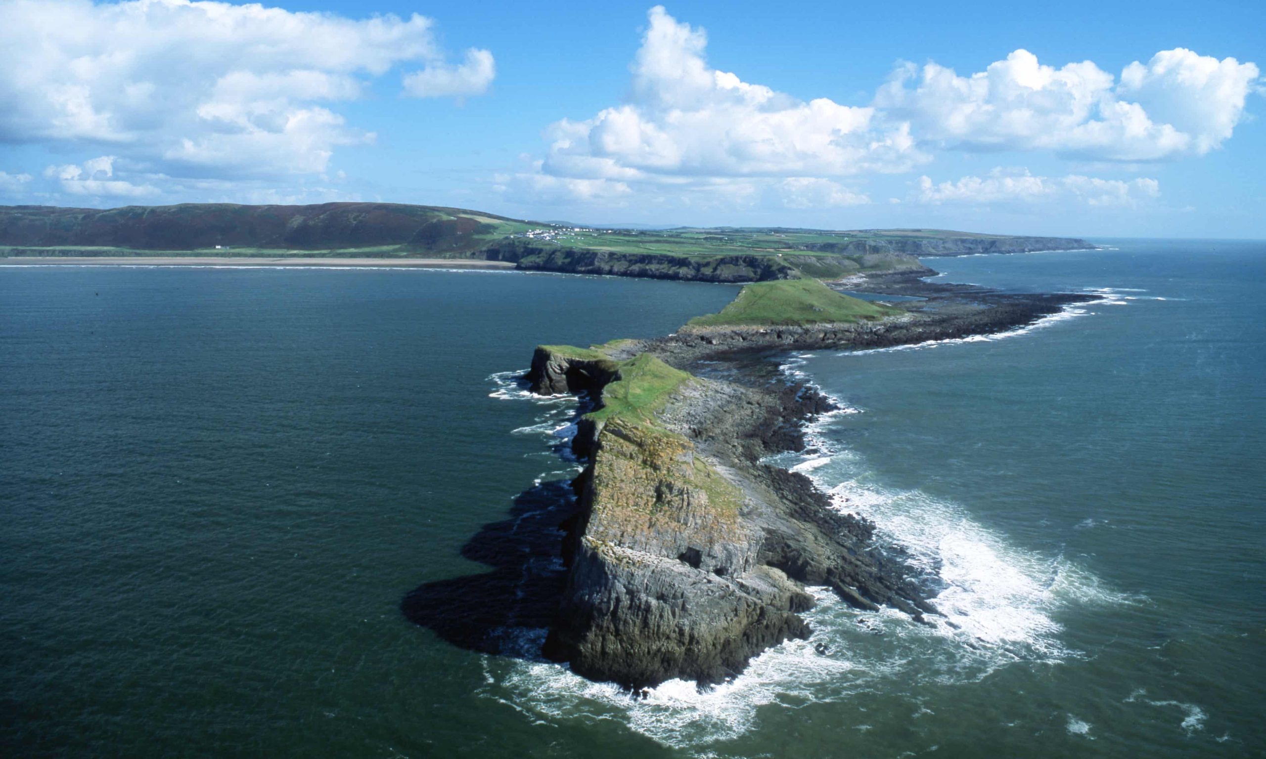
Worm’s Head, Gower peninsula
In a nutshell A rollercoaster route along the rocky dragon’s spine of one of the UK’s most exhilarating islands, full of natural wonders
Distance 7.8km
Walking time 2 hours
Difficulty/terrain Moderate/rocky foreshore, easy paths and steeper scrambles
Looking across from Rhosilli, the steep ridge of the island and the spiralling Outer Head appears to be more the preserve of a mountaineer, but up close it’s a series of thrilling walks and short scrambles. Start at Rhosilli village and follow the coast path above Rhossili Bay. Cross the rocky tidal causeway at low tide on to the island, which is divided into three parts, each joined by low-lying rocky sections that need to be scrambled across.
The first section is the steep-sided, 30-metre flat-topped Inner Head, the south shore of which is flat and grassy and ideal for wild camping. Cross Low Neck, a jagged rock platform carved by the sea leaving deep chasms to scramble over to reach Middle Head, with its spectacular natural rock arch, the airy Devil’s Bridge. Outer Head is a short rock scramble that makes for a spectacular finale with incredible views across the Bristol Channel to Lundy Island.
Getting there Causeway is open 2½ hours before and after low tide – use the BBC tide tables for Mumbles. Outer Head is off limits from 1 March to 31 August to protect nesting birds; the rest of the island is open. though and can be circumnavigated in 90 minutes or so
Stay The Old Rectory overlooking Worm’s Head (sleeps 7 from £1,420 for three nights); or the King Arthur in nearby Reynoldstone (doubles from £85 B&B)
Hilbre island, Wirral

In a nutshell Wave-sculpted cliffs with caves, arches, and geos to explore on an exhilarating estuary walk to a miniature archipelago
Distance 8.3 km
Walking time 2 hours
Difficulty/terrain Moderate/tidal sands and mud; path on island
At the mouth of the Dee, Hilbre is part of a long rocky strand that, together with Little Eye and Middle Eye, forms the mini Hilbre archipelago. You can walk between the islands at low tide (caution is required though, the sea moves fast; safe access is two hours either side of low tide). In the swirling mist, the thrill of crossing the vast sands of Liverpool Bay is heightened by knowing the tide is creeping towards you. On a sunny weekend, though, there’s a happy exodus of picnic-toting folk on a family adventure from surrounding cities.
Starting from Wirral Sailing Centre at West Kirby, head west out on to the sands and the bustle of the seaside town soon gives way to the calls of seabirds and unfurling views of the English and Welsh coastlines. The first of the three islets, Little Eye, feels like a miniature Robinson Crusoe island with golden sands topped by large ferns and colourful wildflowers. Bear north-west and walk over Middle Eye island to Hilbre, accessed via a ramp past sculpted, deep red sandstone cliffs – the Wirral’s own Uluru!
Find your own easy route around Hilbre’s foreshore to discover beautifully sculpted cliffs, caves, stacks, wave-cut platforms and small sandy beaches. There’s also an eclectic mix of buildings, such as the generator that once powered the decoy lights, a bird observatory (part of a national network that monitors migrating birds) and the ruins of a lifeboat station.
Getting there Check the BBC tide tables Hilbre Island. Follow the recommended route – do not cross directly to Hilbre: the mud is dangerous.
Stay Nearby Leasowe Castle (from £79 room-only, £99 B&B) or Victorian country house Peel Hey (doubles from £85 B&B).
Samson, Isles of Scilly

In a nutshell This tiny uninhabited island is a rich and peaceful wildlife haven stacked with ruins dating back to Neolithic times
Distance 3.8 km
Walking time 1½ hours
Difficulty/terrain Easy/rocky foreshore scramble and sandy paths
Step off the boat from St Mary’s (the largest Scilly isle) into the sparkling, clear waters of Bar Point in the north and wade on to the deserted white beach. It’s tempting to stop here and soak up the beauty of Scilly’s largest uninhabited island, but scramble south along the rocky foreshore and it’s not far to the neck of the island between East and West Porth, where ruined fishermen’s sheds sit among wildflower gardens and white sandy beaches. Follow the coast around the southern tip to Tarbarrel Rock, with fabulous views of the rocky western islands. The walk continues past West Porth and on to the northern tip for some great views across to Bryher.
Back at Bar Point, an information board details inland paths for exploring the prehistoric burial grounds of North Hill and the ruined cottages of the abandoned settlement on South Hill, the flora and fauna you’ll encounter and the island’s history. If you’ve seen enough, chill on the beach with a picnic (bring supplies) or brave a swim in the clear sea. From April to September, access to parts of the foreshore may be limited to protect breeding seabirds, and seals starting to pup here from August shouldn’t be disturbed.
Getting there The boat from St Mary’s takes 15 minutes (adult £10, child £5)
Stay The laid-back Mincarlo B&B on St Mary’s (doubles from £83 B&B); or camp at the Garrison on St Mary’s (from £11pp, children half-price)
Scolt Head, Norfolk

In a nutshell A wild walk through sun-warmed channels and one of nature’s great beaches, with plenty of foraging and secluded swims
Distance 13.8km
Walking time 4 hours
Difficulty/terrain Moderate/creek beds, mud banks, sand and shingle beach
Off the coast between Brancaster and Wells-next-the-Sea, this National Trust-owned island is made up of sand dunes, salt marsh, mudflats and shingle, and is renowned for its birdlife. The walk involves crossing two tidal creeks to get to the island – even at low tide there will be some water to wade through.
From Burnham Overy Staithe, a historic harbourside village on the mainland, wade across Overy Creek and one of the finest salt marshes in the UK, with its wealth of samphire, sea lavender, and sea purslane. To reach the island, cross Overy Cockle Strand: at low tide you can walk; at high tide competent swimmers can swim. Once on the island, wade west along the south shore to the head of Norton Creek, where there are plenty of warm and secluded pools to bathe in and great birdlife, including rare terns, spoonbills and glossy ibis. Continue along the creek, and where the Burnham Deepdale path crosses it, turn north to cross the marsh to reach The Hut, a characterful shingle-roofed building used by birdwatchers.
Walk along the wild and extensive sands, shingle and dunes of the north coast, with its rich tangle of colonising grasses, sea holly and orchids, back to the main beach. Swimmers can return to Burnham Overy Staithe simply by letting the incoming tide float them gently back. For a longer, more adventurous route, there’s an option to continue to the western tip before returning along the north shore from The Hut.
Getting there Wade the channels two hours either side of low tide, use BBC tide tables for Hunstanton, which are also posted on the door of the Burnham Overy boathouse. The island can be visited by boat with Peter Bickell (07836 523396, weather permitting from early June to early September, £6 each way)
Stay Pub with rooms The Hero (doubles from £95 B&B) in Burnham Overy
Ynys Giftan, Cardigan Bay

In a nutshell Salt marsh and vast tidal sands with deep, sun-warmed pools framed by majestic Snowdonian mountains and the fairytale turrets of Portmeirion
Distance 4½ km
Walking time 1 hour
Difficulty/terrain Easy/salt marsh, low-tide estuary sand
At the head of the long Dwyryd estuary, one of the most unspoilt places in Cardigan Bay, Ynys Gifftan is surrounded by vast tidal sands, salt marsh and mountains.
From Talsarnau railway station on the mainland, head north-west on the track, then follow the obvious derelict fence line into the salt marsh, a puzzle of gleaming curves of interconnected channels and sun-dried mud hollows rich in wildflowers, with otters, seasonal wildfowl, egrets and herons to spot. Navigate around the larger water-filled channels on dry land – or jump in and squash through the gloopy mud of the channel bottoms.
Cross the tidal sands to the rocks at the southern tip of the island and enjoy the warm, emerald-green pools. These are perfect for diving and swimming in, or simply soaking up views of the fairytale turrets of Portmeirion, the mountains of Snowdonia and the distant ruins of Harlech Castle. Continue around the sands of the foreshore, making for the welcome shade of the trees overhanging the north tip of the island, then explore the ruins of the old farmhouse halfway down the east coast.
Getting there Access two hours either side of high tide: check BBC tide tablesfor Criccieth
Stay For a treat, the four-star Hotel Portmeirion (doubles from £139 room-only, £139, £154 B&B, more in high season); or Edwardian Gwrach Ynys Country Guesthouse (doubles from £70 B&B); or back-of-the-beach camping(from £6 adult, £2 child)
Vallay, Outer Hebrides

In a nutshell Imposing mansion ruins, stunning wildflowers, deserted white beaches and wild camping opportunities
Distance 15.7km
Walking time 4 hours
Difficulty/terrain Moderate/tidal sands, grassy foreshore and dune tracks
Starting from Aird Glas, off the north coast of North Uist, the walk begins with an epic 2km crossing of the tidal sands of Vallay Strand, passing the two smaller islands of Torogaigh and Stangram. Aim for the ruins of the Edwardian house and peer through the windows at its tiled fireplaces, rich red-painted walls and plastered ceilings. Follow the sandy foreshore in a clockwise direction, rounding the island’s western tip to be blown away by the staggering beauty of the wild beaches and the breathtaking views of the St Kilda archipelago – the remotest part of Britain, 60km away.
The white beaches of the north shore are backed by undulating dunes, with the mountains of Harris and the islands of Pabbay and Taransay as a backdrop. The route through the machair continues round the eastern tip – from mid-June to mid-August the palette of green is splashed with the red of poppies and the purples and whites of orchids, clovers, daisies and campanulas. Return along the animal tracks of the south coast, where two standing stones precede the remains of a cross, dun and chapel.
Getting there Vallay Strand may be crossed up to four hours either side of low tide, check BBC tide tables for Loch Maddy
Stay Wild camp (legal in Scotland) on Vallay’s north shore; a swanky treehouse in North Uist (sleeps two from £585 for three nights); or the West Ford Inn, which does great food and has a comfy bothy for two (£85)
Foulness, Essex

In a nutshell Just up the coast from Southend-on-Sea, Essex’s best-kept secret is accessed via the Broomway, a treacherous path through the sands
Distance 29km
Walking time 6 hours
Difficulty/terrain Hard/foreshore walking on the Broomway; easy tracks and paths on the island
From Maplin Sands on the northern bank of the Thames estuary, follow the historic Broomway, where the incoming tide is faster than most people can run and the MoD likes to fire missiles over the beach. The route is a public right of way but it’s generally closed on weekdays. At weekends, though, with a bit of planning, this is one fabulous adventure, but don’t forget your compass.
Starting at Wakering Stairs, head 400 metres out on to Maplin Sands then follow a compass bearing of 61 degrees to the Maypole then 50 degrees along the foreshore to walk the 9.7 km stretch of monochrome sand and sky that meets at the silver line of the distant North Sea. Access the island at Fisherman’s Head, follow paths past quaint weatherboard and brick houses to Crouch Corner on the north shore, then continue along the River Crouch. Inland, the landscape is dotted with mysterious watchtowers, launch towers, strange domes and fenced compounds. Turn south alongside the River Roach and inland to Church End and the heritage centre housed in a dilapidated Gothic church and home to an eclectic mix of island artefacts, plus tea and cakes. Return along the Broomway via Rugwood Head.
Getting there The Broomway is dangerous three hours before high tide. It is usually wet, so take appropriate footwear and always check access with MoD Shoeburyness.
Stay Hamilton’s Boutique Hotel on the historic Royal Terrace in Southend (doubles from £85 B&B).
Alderney, Channel Islands

In a nutshell A fortified coastal path with dramatic cliffs, exuberant wildlife and secret underground tunnels to explore by torchlight
Distance 18.2 km
Walking time 4½ hours
Difficulty/terrain Easy/undulating coastal path, optional steeper sections
Alderney (not part of the UK, but too good to miss) offers lots of contrast: in the north there’s the greatest concentration of military fortifications and beaches, while the south is all about incredible wildlife and cliffs.
Start at Braye Harbour and head west along the north coast to Fort Tourgis, the largest of the Victorian fortresses and a great place to explore. Clonque Bay beach is a favourite for rockpoolers and leads to the spectacularly located Fort Clonque. Ascend a rugged path to the clifftops for great views of the uninhabited island of Burhou, with its colonies of puffins, and at the western tip, Les Étacs, a rocky outcrop crowned white by a swirling colony of gannets (2% of the world’s population of northern gannets).
On the south coast, pass the Wildlife Bunker, once home to a German signals crew and now a celebration of the island’s nature, with glossy interpretation boards. Continue to the west end of Longis Bay for a well-earned rest at the Old Barn, a great place for lunch or afternoon tea. Continue along the bay past the tidal causeway to Raz Island. The north coast return route offers wonderful swimming at Corblets Beach, adjoining Arch Beach and neighbouring Saye Bay. Just beyond, explore Bibette Head’s tunnels and underground rooms with a torch before returning to Braye past Fort Albert and the large curve of Braye Bay.
Getting there Ferries run from Guernsey between 24 May and 29 September (from £50 return). Ferries run to Guernsey from Poole and Portsmouth (from £34pp one-way, condorferries.co.uk)
Stay Pub with rooms The Georgian House (doubles from £100 B&B) ; or camp at Saye Beach (adult from £7, child half-price, equipped tent hire from £45)
Steep Holm, Bristol Channel

In a nutshell Enjoy panoramic views from a former military outpost turned nature reserve
Distance 2.2km
Walking time 45 minutes
Difficulty/terrain Easy/easy paths, optional steep and exposed cliff paths
As you bounce over the waves on an exhilarating RIB ride from Weston-super-Mare, this mysterious lump of rock slowly comes into view: outlines of ruined buildings emerge on the cliffs, conjuring images of smugglers and pirates swigging liquor.
From the landing beach, climb the zigzag path past the ruins of Cliff Cottage and Inn and on through wind-stunted sycamore woods. On the plateau, take the easy path along the south coast past the barracks, home to the island’s museum, cafe and tranquil gardens and a good place to spot giant slow worms and rare Mediterranean wild peonies. Continue to Split Rock Battery, a favourite nesting site for gulls, and head into one of the underground munitions stores to search for the large egg sacks of the Culvert spider that hang from the ceiling before reaching Rudder Rock Battery, on the dramatic sea arches of the island’s west tip. Superb views unfold of the Somerset and south Wales coastlines across the Bristol Channel. Along the north coast, explore more military ruins. Return to the Barracks or take an optional steep descent to South Landing to see the lime kiln. At low tide rock-hop back to East Beach if the birds have finished nesting.
Getting there By boat from Weston or Cardiff with Bay Island Voyages (£40 return, £35 child, call 07393 470476 to book). More details at steepholm.org.uk
Stay A secluded shepherd’s hut a short distance from Weston (sleeps two from £100)
Holy Isle, Firth of Clyde

In a nutshell A Tibetan Buddhist vision realised on an unspoilt island where residents live in harmony with nature
Distance 8.7 km
Walking time 2½ hours
Difficulty/terrain Moderate/steep climbs on rugged paths, easy path along west coast
With towering peaks, retreat centres and tranquil gardens, Holy Isle has a lot in common with Tibet. The ferry from Arran island takes 10 minutes, but it feels a world away. The walk starts with an introduction to the island given by a monk among large white stupas and fluttering prayer flags. Then you are on your own. The first half of the hike is through wood and moorland on the rugged path over Mullach Beag and Mullach Mòr, the highest point on the island. On the steep downhill leg, small hermit-like cells half-buried in the hillside are the homes of two nuns on a lifetime retreat.
The second half of the walk is via the gentler coastal path past sacred caves covered with the marks and crosses of runic inscriptions and large and colourful paintings of Buddhist deities on rocks along the shoreline. Closer to the retreat centre, fruit-filled orchards and vegetable-stacked gardens are tranquil places to wait for the returning ferry.
Getting there Day visitors are advised to book the boat from Arran (£12 return)
Stay On a summer retreat (doubles from £92) on the island; a yurt on Arran(from £70, sleep two to six); or wild camp (legal in Scotland) on the east coast of Arran at Glen Sannox, north of Brodick
The Guardian


Leave a comment